
Myanmar earthquake a serious warning for Tehran
Myanmar earthquake a serious warning for Tehran
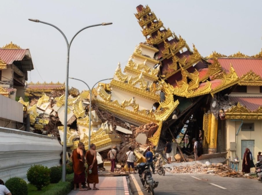
The earthquake that shook Myanmar on the eighth of Farvardin was not merely a momentary natural event, but the result of tension that had accumulated within the earth over two centuries.
This powerful earthquake, with a magnitude of 7.7, not only caused the death of over 2,700 people and widespread destruction in Myanmar itself but also affected Bangkok, the capital of Thailand, more than a thousand kilometers away.
Now, geologists, in their warnings, are anxiously looking at regions like Tehran, where repeated warnings about hidden explosions underground have been ignored for years. In the case of Myanmar, experts explain that last week’s earthquake was the result of tension accumulated over 200 years.
Dr. Martin Kaiser, a professor of geophysics at Ludwig Maximilian University of Munich and head of the geophysical hazards section at Munich Re insurance company, tells the German news agency that the tension accumulated between the Indian plate and the Eurasian plate in the Myanmar region was suddenly released during this major earthquake.
According to him, these two tectonic plates move past each other at a speed of about two centimeters per year.
Dr. Kaiser added, now imagine how much tension can accumulate at the boundary of these two plates over two centuries, tension that eventually led to a five to six-meter displacement of the earth.
The Myanmar earthquake occurred along the Sagaing fault, one of the most important active faults in Southeast Asia.
This fault stretches as a deep north-south cut across the country and has long been under the scrutiny of seismologists.
But perhaps even they did not predict that such an earthquake could affect the capital of a neighboring country at a distant location.
The loose soil, the second alarm
Bangkok shook despite being a thousand kilometers away from the earthquake’s epicenter.
According to Kaiser, this tremor covered such a range because Bangkok is situated on a bed of loose and deep sediments of the Chao Phraya River, sediments that have accumulated over thousands of years. This soft and thick soil transmitted the low-frequency earthquake waves with greater intensity and increased the amplitude of the oscillations.
Similar conditions in Tehran
Now, all eyes are on Tehran, a capital not only located on major active faults like the North Tehran Fault, the Rey Fault, and the Mosha Fault, but many of its areas are also built on loose alluvial soils.
Especially in the south and southeast of Tehran, the depth of sedimentary layers is significant, and this feature has worrying similarities with the geological conditions of Bangkok.
The last major earthquake in Tehran occurred on March 27, 1830, more than 190 years ago, with a magnitude of over seven degrees. Reports indicate that the regions of Shemiranat and Damavand were almost completely destroyed, and about 70 villages east of Jajrud were wiped out. The Mosha Fault is about 200 kilometers long and is one of the main faults of the Central Alborz, located north of Tehran.
The accumulation of seismic force in the Tehran region over more than 190 years has led earthquake experts in Iran to warn for years, given the unsuitable urban fabric and weak facilities, about the occurrence of a major disaster in the event of an earthquake in the capital and emphasize that many hospitals are also at risk of destruction.
Ahmad Khoram, the head of the Tehran Building Engineering System Organization, previously stated that even in an earthquake with a magnitude of 6.5, we should expect casualties exceeding one and a half million people in Tehran. A high-magnitude earthquake in Tehran is not a fictional scenario. Studies by the National Geological Organization, the International Institute of Earthquake Engineering and Seismology, and even UN reports have shown that the likelihood of a high-magnitude earthquake occurring in Tehran is not only serious but has long been overdue.